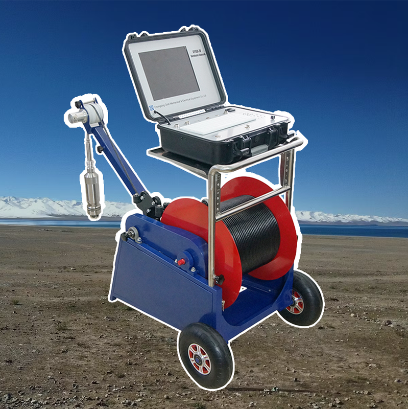
Máy ảnh kiểm tra lỗ khoan quay GYGD-IV: Khám phá lịch sử ngầm mà không làm gián đoạn nó
Các nhà khảo cổ học và quản lý di sản văn hóa thường cần nhìn vào bên trong các giếng cổ, bể chứa nước, phòng chôn cất và hệ thống đường hầm mà không cần khai quật hoặc làm hỏng các cấu trúc mong manh.Máy ảnh kiểm tra lỗ khoan quay GYGD-IVlà mộtCông cụ điều tra không xâm lấncung cấptruy cập hình ảnh độ trung thực caođể thu thập thông tin chi tiết về kỹ thuật xây dựng, dấu hiệu công cụ, khắc và vị trí hiện vật mà không cần bất kỳ sự xâm nhập vật lý nào.các nhà khảo cổ học, nhân viên bảo tồn lịch sử và quản lý tài nguyên văn hóa, máy ảnh này mở ra một cửa sổ vào quá khứ mà vẫn hoàn toàn không bị quấy rầy.
Việc triển khai cực nhẹ với sự xáo trộn bề mặt tối thiểu
Các GYGD-IVđầu dò đường kính nhỏ(75 mm) có thể đi vào các lỗ hổng hiện có, vỏ giếng cũ, ống thông gió hoặc thậm chí các vết nứt trong xây dựng, mà không cần phải đào hoặc sửa đổi các mô lịch sử.nón mũi mềmvàVòng xoắn trung tâmđược làm bằng polyurethane không thô ngăn ngừa trầy xước hoặc vỡ đá cổ hoặc thạch cao.cápđược bao bọc trong mộtVải đan mềmToàn bộ hệ thống có thể được vận hành bởi mộtngười độc thântừ bề mặt, không để lại dấu vết của cuộc điều tra.
Tài liệu có độ phân giải cao để xuất bản và bảo tồn
Các GYGD-IVhình ảnh tĩnh mười hai megapixelNhận các chi tiết như dấu vết thép, thành phần vữa, vết bẩn trên mực nước, và thậm chí những dòng chữ mờ.cảm biến hiệu chuẩn màuđảm bảo tái tạo chính xác các sắc tố và mảng màu.360 độ xoaycho phép tài liệu đầy đủ của không gian hình trụ như giếng và bể chứa, tạo ra mộthình ảnh toàn cảnh liên tụcNhững hình ảnh này phù hợp vớiấn phẩm được đánh giá ngang hàng, triển lãm bảo tàng và lập kế hoạch bảo tồn.
Xem từ xa để tham khảo ý kiến chuyên gia mà không cần truy cập trang web
Nhiều di tích khảo cổ nằm ở những khu vực xa xôi hoặc nhạy cảm về mặt chính trị, hoặc quá mong manh để cho phép nhiều nhà nghiên cứu tại địa điểm.khả năng phát trực tiếpcho phép một nhà khảo cổ học dẫn để xem kiểm tra từ bất cứ nơi nào trên thế giới, hướng dẫn các nhà khai thác địa phương đến các khu vực quan tâm.tính năng chú thíchcho phép các chuyên gia từ xa đánh dấu các tính năng để nghiên cứu sau này.tư vấn từ xaGiảm nhu cầu đi lại, bảo tồn các trang web mong manh và tăng tốc phân tích.
Ghi âm theo ngữ cảnh với dữ liệu không gian
Các GYGD-IVbộ mã hóa độ sâucung cấp vị trí thẳng đứng chính xác, thiết yếu để tạo racác bản ghi tầng lớp.ốc độ nghiêng tùy chọnđo độ nghiêng của đầu dò, cho phép điều chỉnh cho các giếng ngoài dọc.Máy nhận GPSghi lại tọa độ đầu giếng. Tất cả dữ liệu có thể được xuất sangGIS (hệ thống thông tin địa lý)vàPhần mềm mô hình 3D(chẳng hạn như Agisoft Metashape hoặc RealityCapture) để tạosinh đôi kỹ thuật sốcủa di sản ngầm.
Nghiên cứu trường hợp: Tài liệu giếng thời La Mã
Một nhóm các nhà khảo cổ học đã sử dụng GYGD-IV để ghi lại một giếng La Mã sâu mười hai mét trong một khu vực được bảo vệ nơi mà việc khai quật bị cấm.hầm gỗ được bảo tồn đáng chú ý,Dấu hiệu công cụ phù hợp với những cái cào La Mã, và ở phía dưới, mộtthùng gốm vỡCác hình ảnh độ phân giải cao cho phép nhóm công bố một bài báo về kỹ thuật xây dựng giếng La Mã mà không bao giờ loại bỏ một cổ vật duy nhất.

Bảng: Thông số kỹ thuật khảo cổ