logo
Chongqing Gold Mechanical & Electrical Equipment Co.,Ltd
Email: master@hy-industry.com TEL: 0086-159-2263-6015
Home > PRODUCTS > Magnetic Survey Instruments >
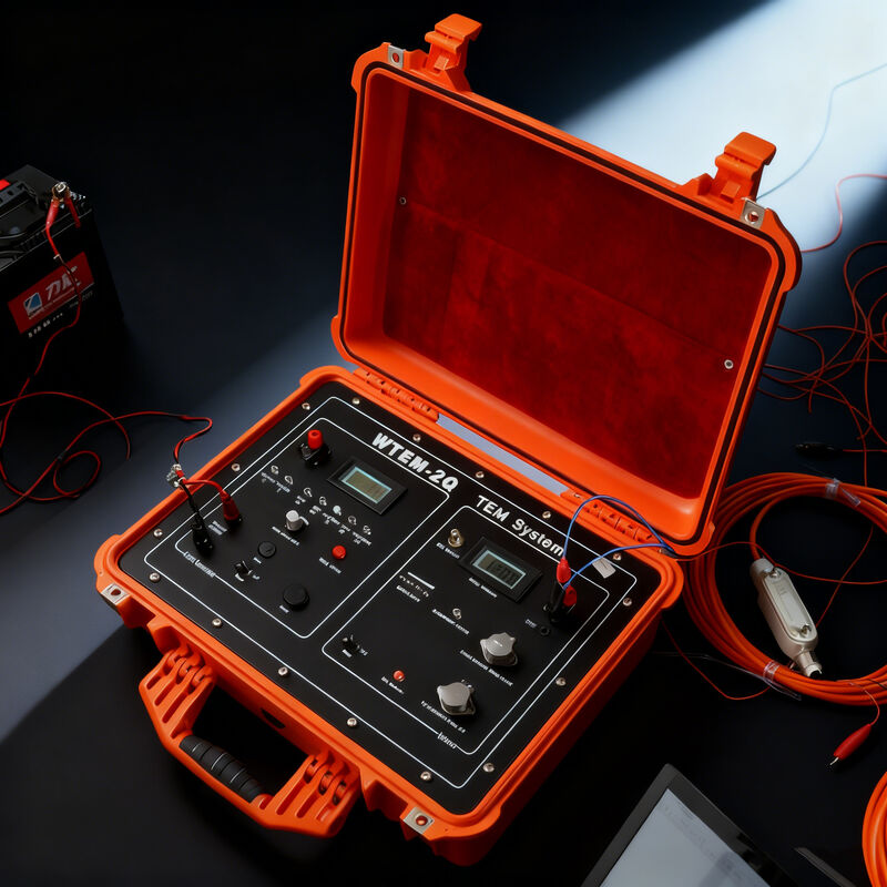
WTEM-3Q Model Transient Electromagnetic Instrument for Geological Survey and Environmental Monitoring with GPS Synchronization
  • WTEM-3Q Model Transient Electromagnetic Instrument for Geological Survey and Environmental Monitoring with GPS Synchronization
  • WTEM-3Q Model Transient Electromagnetic Instrument for Geological Survey and Environmental Monitoring with GPS Synchronization
  • WTEM-3Q Model Transient Electromagnetic Instrument for Geological Survey and Environmental Monitoring with GPS Synchronization
  • WTEM-3Q Model Transient Electromagnetic Instrument for Geological Survey and Environmental Monitoring with GPS Synchronization
  • WTEM-3Q Model Transient Electromagnetic Instrument for Geological Survey and Environmental Monitoring with GPS Synchronization
  • WTEM-3Q Model Transient Electromagnetic Instrument for Geological Survey and Environmental Monitoring with GPS Synchronization
  • WTEM-3Q Model Transient Electromagnetic Instrument for Geological Survey and Environmental Monitoring with GPS Synchronization

WTEM-3Q Model Transient Electromagnetic Instrument for Geological Survey and Environmental Monitoring with GPS Synchronization

Place of Origin chongqing,China
Brand Name GOLD
Certification CE, ISO
Model Number WTEM-3Q
Product Details
Application:
Geological
MOQ:
1
Keyword:
Electromagnetic Measuring Instruments
Feature:
High Accuracy Low Cost
Usage:
Geological Problems
Brand:
Gold
Type:
Magnetic
Operating Temperature:
-10°C~50°C
Key Words:
Transient Electromagnetic Instrument
Model:
WTEM-3Q
Highlight: 

Geological Survey Transient Electromagnetic Instrument

,

Environmental Monitoring TEM System

,

GPS Synchronization Geophysical Survey Equipment

Product Description
Shallow Transient Electromagnetic Instrument for Soil and Groundwater Pollution Monitoring
Shallow Transient Electromagnetic Instrument in field use

The WTEM System provides essential environmental geology applications for monitoring soil and groundwater contamination, assessing geological stability at waste disposal sites, and supporting environmental impact assessments. It effectively delineates contaminated zones and characterizes subsurface materials to develop remediation strategies for polluted areas.

WTEM-2J/GPS TEM Exploration System Receiver
Specification Details
Channel number 1
Pre-amplifier gain 8, 32 times
Main amplifier gain 1, 2, 4, 8, 16, 32, 64, 128 times
Band pass 0~50kHz(liner phased filter), full band 0~400kHz
A/D bit 16bit
The minimum sample interval 1 μs
Crystal oscillation total error ≤5*10-9
Trace number 50
Stack number 1~9999
Synchronization mode (1) Cable synchronization (2)GPS synchronization
Power supply Built-in 12V rechargeable battery(support outside power), working time≥10 hours
Working temperature -10℃~+50℃
WTEM-1D 10KW Large Power Transmitter
Specification Details
Transmitting voltage 200V
Transmitting current 50A
Current measurement precision 1%
Power supply frequencies 0.0625Hz, 0.125Hz, 0.25Hz, 0.5Hz, 1Hz, 2Hz, 4Hz, 8Hz, 16Hz, 32Hz
Transmitting power voltage display Liquid crystal display unit V, display resolution 0.1V
Working temperature -10℃~+50℃
Additional Specifications
Operating temperature -10℃~+50℃
Charger for built-in battery 12V, charging current ≤1.5A, charging time ≤6 hours (automatic detection)
Charger for transmitting battery 12V, charging current ≤20A, charging time ≤10 hours
Processing Software

Includes Windows version of one-dimensional forward and inversion software, Surfer software, data transmission and format conversion software, enabling quick data playback, processing, and mapping.

Key Advantages
  • High construction efficiency with pure secondary field observation and sensitivity to low-resistance bodies, making it ideal for coalfield hydrogeological exploration
  • Combined observations at the same point provide optimal coupling with detection targets, strong abnormal response, and simple morphology
  • Simultaneous profile measurement and depth measurement provide comprehensive subsurface information
  • Effective in identifying electrical characteristic differences in rock formations for mineral resource detection
  • Often combined with other exploration methods to improve accuracy and reliability
  • Particularly valuable for finding hidden minerals where conventional methods face challenges
TEM instrument in field operation Close-up of TEM equipment TEM data collection process TEM system components TEM field survey setup
Main Applications
  • Adaptable configuration for various geological problems including quick surveys, stereo mapping, deep mine finding, and shallow detection
  • Ideal for metal mineral, coal, oil and gas field, geothermal field exploration
  • Effective for hydrogeological and engineering geological surveys
TEM system in mineral exploration TEM equipment setup for field work

Contact Us at Any Time

0086-159-2263-6015
Building 26 , Yubei Intelligent Manufacturing Industrial Park,Liangjiang District, Chongqing, 401120, China
Send your inquiry directly to us