Das statistische Instrument zur Charakterisierung der Unterfläche
Moderne geotechnische und Ressourcenmodelle bauen auf quantitativen Daten auf, nicht nur auf visuellen Beschreibungen, sondern auch auf statistisch aussagekräftigen Messungen, die eine probabilistische Analyse und Risikobewertung unterstützen.GD-C1201 Intelligenter Bohrloch-optischer BildnehmerFunktionen alsstatistische Charakterisierungsinstrument, die es Ingenieuren und Geologen ermöglicht, visuelle Beobachtungen innumerische DatensätzeDieses System bringt statistische Strenge zum Bohrloch,Jede Untersuchung in eine Quelle empirischer Verteilungen statt anekdotischer Beobachtungen zu verwandeln.
Kennzeichenquantifizierung
Die Messinstrumente der Software sind darauf ausgelegt,Wiederholbare, vom Betreiber unabhängige Quantifizierung. DieRissbreitenextraktionEr erfasst mit einer Genauigkeit von 0,1 mm senkrechte Abstände über Frakturen und erzeugt so eine kontinuierliche Datenserie von Öffnungen über das erfasste Intervall.OrientierungsextraktionDie Ergebnisse der Datenbank ergeben sich aus einem Datenbestand, der auf Stereonets gezeichnet, in Gelenksätze gruppiert und auf mittlere Orientierung und Dispersion analysiert werden kann.FlächenextraktionDas Werkzeug misst die Abmessungen der Leer- oder Veränderungszonen und liefert damit Flächenschätzungen für die volumetrischen Berechnungen.Kernattributblatt, die als strukturierte Datenbank funktioniert, die zur statistischen Analyse mittels integrierter Funktionen, Pivottabellen und Grafiken in Excel exportiert werden kann.
Datenpopulation und Stichprobengröße
Im Gegensatz zum Kernlogging, bei dem nur wiederhergestellte Intervalle verfügbar sind (oft weniger als 70% im gebrochenen Boden), werden die GD-C1201-Bilder100% der BohrlochwandDiese vollständige Abdeckung erhöht die Stichprobengröße für Strukturmessungen drastisch.Verglichen mit nur den wiedergewonnenen StückenGrößere Stichprobengrößen reduzieren die statistische Unsicherheit und ermöglichen zuverlässigere Schätzungen des mittleren Bruchstands, der Orientierungsverteilung und der Blendefrequenz.Für Projekte, die eine probabilistische Planung erfordern (eDiese Datendichte ist für Monte-Carlo-Simulationen und Zuverlässigkeitsbewertungen unerlässlich.

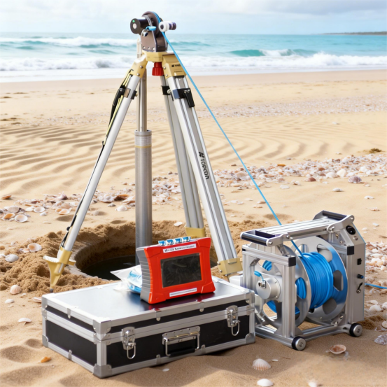
Technische Spezifikationen: Die statistische Maschine
Integration mit Modellierungssoftware
Die exportierten Excel- und CSV-Dateien können direkt in spezialisierte geostatische und Modellierungspakete wie Leapfrog, Datamine, DIPS und RocData importiert werden.Das strukturierte Format des Systems sorgt dafür, dass die Attribute (Tiefe, Orientierung, Blende, Typ) vorab gekennzeichnet sind, wodurch die Notwendigkeit einer manuellen Umformatierung entfällt.alle Frakturen innerhalb eines bestimmten Tiefenintervalls mit Öffnungen von mehr als 2 mm für gezielte AnalysenDieser nahtlose Datenfluss beschleunigt den Prozess des Modellbaus und ermöglicht es den Ingenieuren, mehr Zeit für die Interpretation und weniger Zeit für die Vorbereitung der Daten zu verbringen.
Das Urteil des quantitativen Geologen
Die GD-C1201 verwandelt Bohrlochforschung von einer beschreibenden Kunst in eineMesswissenschaftEs bietet dieDatendichte und -genauigkeitDie Daten sind für eine solide statistische Charakterisierung erforderlich, die es Fachleuten ermöglicht, Unsicherheiten zu quantifizieren, Trends zu identifizieren und ihre Modelle mit empirischen Beweisen zu verteidigen.Messbare, wiederholbare und statistisch analysierbare Daten, dieses System entspricht der wachsenden Nachfrage der Industrie nach evidenzbasiertem Design und risikoorientierten Entscheidungen.

 Ihre Nachricht muss zwischen 20 und 3.000 Zeichen enthalten!