Multifunctionele geofysisch hulpmiddel voor prospectie van minerale en civiele techniek
Een veelzijdig geofysisch hulpmiddel voor gelijktijdige RES- en IP-enquêtes, het is ideaal voor metaal/niet-metaal minerale exploratie en civiele geofysische verkenning. Het zendergedeelte biedt een maximaal vermogen van 6600 W voor algemeen res/ip -klinken. Het weegt ≤4,4 kg voor eenvoudig transport.
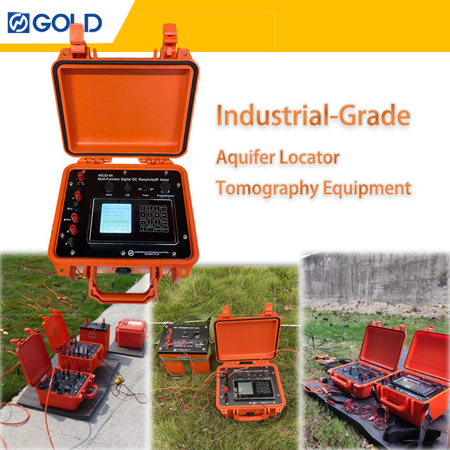
Productbeschrijving

De WDJD - 4A is een geofysisch verkenningsinstrument dat een revolutioneert van ondergrondse onderzoek. Het maakt gelijktijdige weerstand (Res) en geïnduceerde polarisatie (IP) -onderzoeken mogelijk met een perfecte combinatie van hoge nauwkeurigheid, snelle snelheid, hoge betrouwbaarheid en uitstekende uitbreidbaarheid.
Dit veelzijdige instrument wordt op grote schaal op verschillende gebieden gebruikt. Op het gebied van minerale hulpbronnen speelt het een cruciale rol in zowel metaal- als niet -metaal minerale verkenning, waardoor potentiële ertslichamen worden vastgesteld. Voor civiele techniek ondersteunt het geofysische exploratie voor infrastructuurprojecten zoals spoorweg-/brugvervoer om ondergrondse omstandigheden te beoordelen. Bovendien is het zeer effectief bij het detecteren van grondwater, het vinden van verborgen gevaren in damfunderingen en overstromingscontrole dijken, evenals voor hydrologische, engineering en geothermische prospectie.
Of u nu op zoek bent naar waardevolle mineralen, zorgt voor de veiligheid van civiele techniekstructuren of het verkennen van grondwaterbronnen, de WDJD - 4A biedt nauwkeurige en betrouwbare gegevens om geïnformeerde beslissing te stimuleren - het nemen van een geïnformeerde beslissing.
Bekijk uw geofysische gegevens met uitgebreide intelligentie -integratie.Ons platform combineertMeerdere gegevensstromennaar binnenbruikbare inzichtendoor middel van geavanceerde verwerkings- en visualisatietools.
Integratiemogelijkheden:
-
Multi-source gegevensfusievanVerschillende sensortypen
-
Cross-platform compatibiliteitmetIndustriestandaarden
-
Cloud-gebaseerde verwerkinghet mogelijk makenexterne samenwerking
-
Aanpasbare uitgangenvoorSpecifieke projectvereisten
Gegevensintegratiematrix:
Volledige data -eenheid bereikenmet ons geïntegreerde intelligentieplatform.
V1: Kan de WDJD - 4A worden gebruikt in extreme temperatuuromgevingen?
A1: Ja, het kan werken binnen een temperatuurbereik van - 10 ° C tot + 50 ° C tijdens de werking en worden opgeslagen in omgevingen van - 20 ° C tot + 60 ° C, waardoor het geschikt is voor de meeste veldomstandigheden.
V2: Hoe lang duurt de interne batterij?
A2: De interne oplaadbare batterij van 12V 9AH kan maximaal 30 uur duren, waardoor lange enquêtes met lange duur mogelijk zijn.
V3: Is training beschikbaar voor het bedienen van de WDJD - 4A?
A3: Ja, we bieden uitgebreid trainingsmateriaal en kunnen aanbieden op - site- of online trainingssessies om ervoor te zorgen dat gebruikers het instrument bekwaam kunnen werken.
V4: Wat is de garantieperiode voor de WDJD - 4A?
A4: We bieden een garantie van 1 jaar voor niet -man - schade aangericht. Tijdens de garantieperiode bieden we gratis reparatie of vervanging van defecte onderdelen.

 Uw bericht moet tussen de 20-3.000 tekens bevatten!